3 key California storm images from a satellite launched just in time to capture the drama
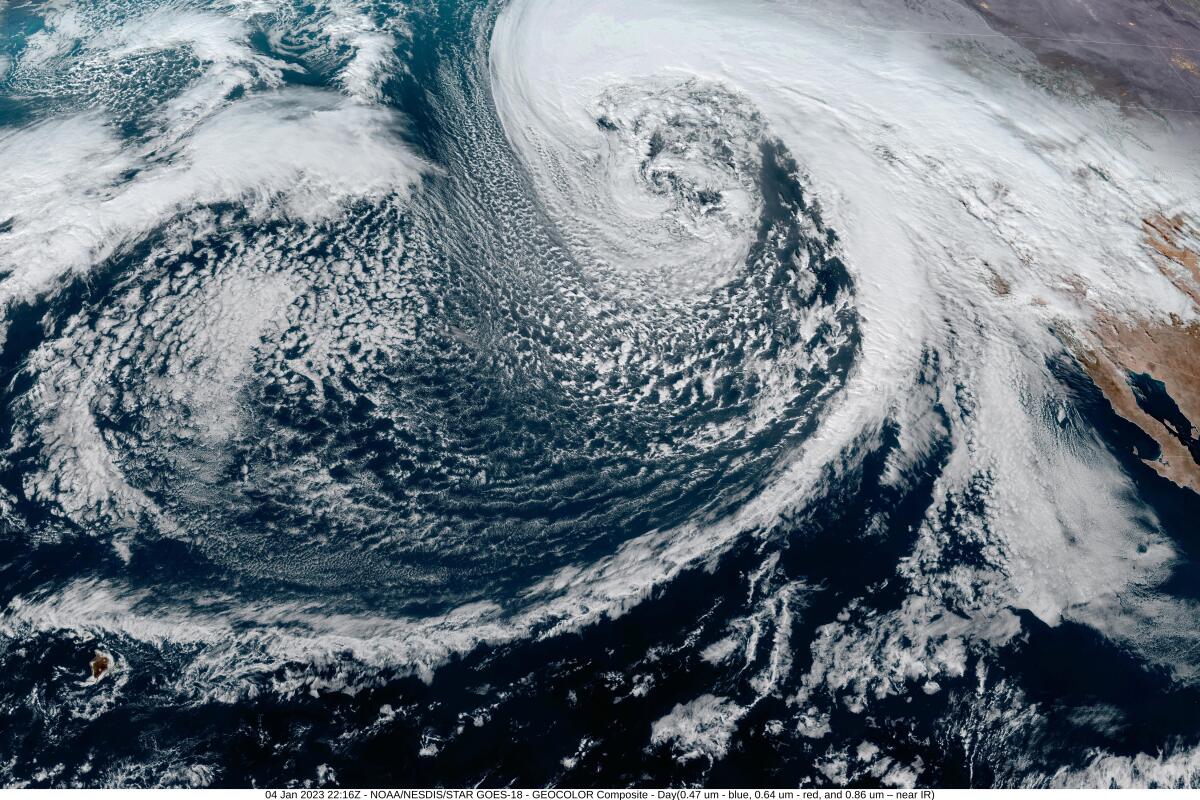
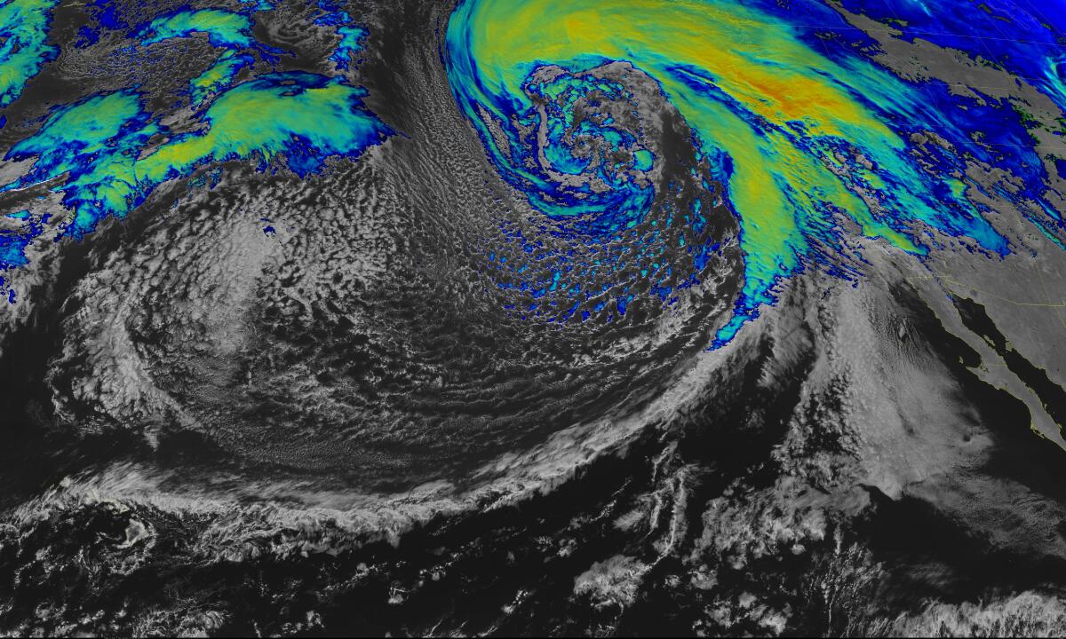
Images from a newly operational government satellite show the extent of the storm system passing over California this week — including the dramatic whorl of a “bomb cyclone” as it gains strength and the whipping tail of an atmospheric river.
On Wednesday, GOES-18, a satellite launched by the National Oceanic and Atmospheric Administration in March, went into operation and produced the striking images of the storm off the West Coast.
GOES-18 captured the data to create these images by flying much higher than most other satellites, said Dan Lindsey, a program scientist with NOAA’s GOES-R program. The satellite flies about 22,000 miles above Earth and orbits at the same rate as the planet spins, allowing cameras to capture multiple images over time from the same angle.
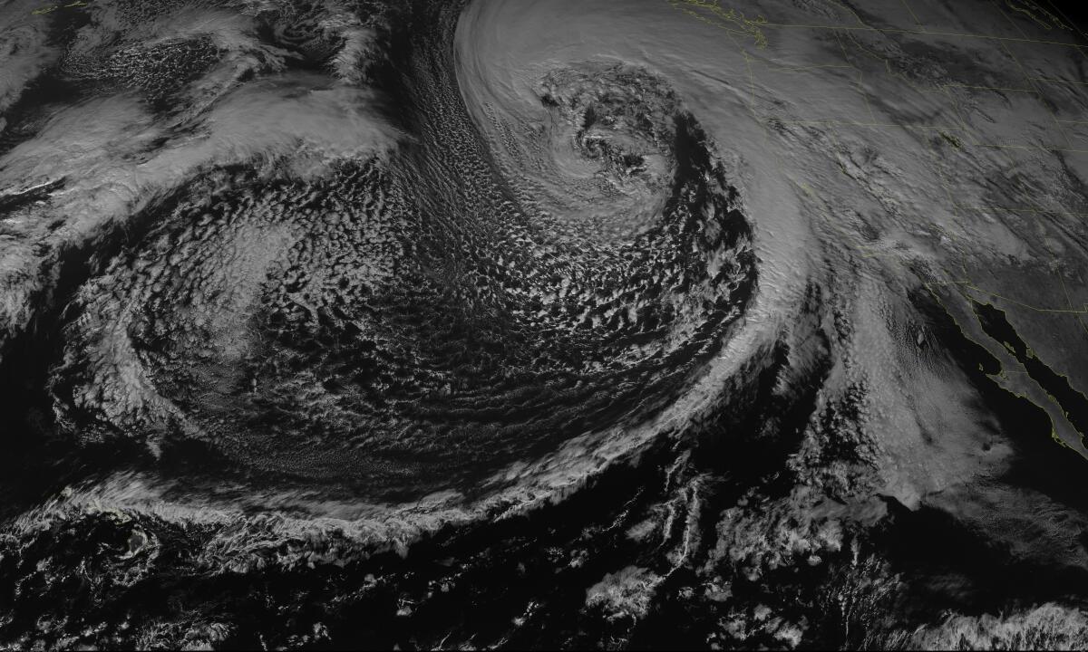
Below is an image captured from a single wavelength in the red portion of the visible spectrum. It allows a viewer to see what they would see from space, but in black and white. Or, as Lindsey put it, “a very classic-looking comma-head mid-latitude cyclone with a cold front heading down.”
The “sandwich” image below shows the coldest clouds and the punch of precipitation they could be packing as they head toward California’s coast.
The image combines some visible-band — or reflective — radiation with infrared readings to show outlines of the clouds in black and white and give a sense of the temperature of the coldest clouds by using color. These clouds tend to be the highest in the atmosphere, and high clouds typically produce rain and snow.
As the color goes from blue and green to yellow and orange, the clouds get colder and likely higher in altitude.
Most of the time, weather systems affecting the West Coast come from the Pacific, Lindsey said. Mid-latitude cyclones like the one approaching California typically move west to east, bringing water vapor from the ocean and spinning counterclockwise in the Northern Hemisphere.
As a cold front — the edge of a storm — hits warmer air over land, clouds can be stretched upward and create rain, he said.
The “strong area of rotation in the middle” of the storm corresponds to a bomb cyclone, said Adam Roser, a meteorologist at the National Weather Service in San Diego. A bomb cyclone is an “area of low pressure that drops very quickly,” he said, adding that the cyclone is gaining strength.
The tail is the “cold frontal boundary” also known as an atmospheric river, which is bringing stormy weather to California. Those windy, rainy conditions were impacting Northern California on Wednesday morning, and Roser expected them to move farther south by evening. “Heavy rainfall, windy conditions, high swell and high surf” could be expected, he said.
This week’s storms could be the strongest to hit Northern California since the El Niño-fueled winter of 1997-1998, leading Gov. Gavin Newsom to declare a state of emergency to “support response and recovery efforts.”
Meanwhile, in Southern California, residents were bracing for a significant storm event, which brought evacuation notices for some residents and a roadway closure.
More to Read
Sign up for Essential California
The most important California stories and recommendations in your inbox every morning.
You may occasionally receive promotional content from the Los Angeles Times.

