The same elements that made the Thomas fire such a monster also created deadly debris flows

Santa Barbara County crews worked through the holidays to defend coastal communities from the second half of Southern California’s familiar cycle of fire and flood.
They cleaned out the 11 debris basins that dot the Santa Barbara front country, making room for the dirt and ash and rocks that winter rains would inevitably send tumbling down mountain slopes laid bare by the massive Thomas Fire.
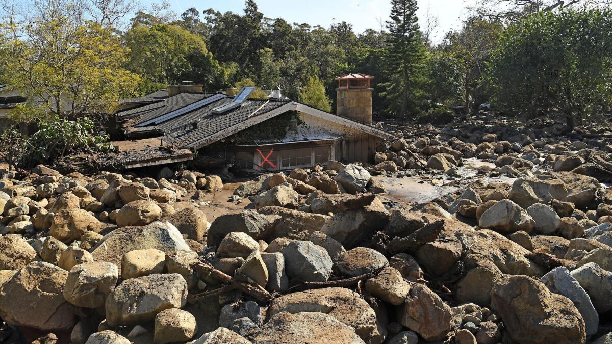
But when the first major storm of the season slammed into the coast Monday, the thundering deluge of mud, car-sized boulders and trees that fell upon Montecito was beyond anything they expected.
Triggered by a band of intense rain — which at one point early Tuesday dumped a half inch in five minutes — the runoff gathered force in gullies and creek beds, collecting more and more deadly cargo as it blasted past the debris basins into wealthy hillside neighborhoods.
The Thomas fire was halted on the steep slopes just above Montecito, sparing the enclave. But the same dramatic landscape that made the Thomas fire so hard to fight propelled rivers of mud and rock on a devastating rampage, toppling houses, tossing cars around like pieces of Legos and carrying 3-foot-wide boulders all the way to the beach.
“It’s almost unimaginable what I saw today,” Tom Fayram, deputy public works director for Santa Barbara County, said Wednesday after a helicopter flight over the region.
Multiple debris flows dotted 13 miles of the front range. The basins his crews frantically emptied last month were “all chock full of rocks and debris,” including the largest, which has a capacity of more than 20,000 dump trucks.
Some of the basins were constructed after the 1964 Coyote fire and the 1971 Romero fire burned large watersheds, setting the stage for floods and debris flows.
“We’ve seen pictures of debris flows from the Coyote fire in 1964 and large rocks were moved down. But nowhere near the scope of what happened here,” Fayram said.
Heavy rain on steep slopes can trigger a flow without a fire, but big burns are a typical ingredient of Southern California debris flows.
“That’s something we’ve known since the early to mid-20th century,” said Josh West, an associate professor of earth sciences at USC. “It’s this one-two punch of fire and debris flows.”
Not only does an intense wildfire consume the vegetation and shallow root system that holds soil in place; it can also turn slopes into a raincoat that repels rather than absorbs water.
Scientists aren’t precisely sure how that happens, said Jonathan Godt, a natural hazards program coordinator for the U.S. Geological Survey.
But it probably involves two processes: Volatilization of organic compounds in the soil creates waxy substances that coat sediments. And fire dries the soil to such a degree that it loses the ability to soak up rainfall, like a shriveled sponge.
On top of that, Southern California’s mountain ranges are steep and highly erodible. And because of tectonic plate movement, they are slowly rising. “What goes up must come down,” West said.
Based on past data, the USGS has found that debris flows are likely to occur in Santa Barbara burn areas if rainfall rates hit a half inch per hour, said Francis Rengers, an agency research geologist.
They far exceeded that threshold in Tuesday’s pre-dawn hours, effectively turning a fire hose on the barren, fire-baked front country of the Santa Ynez Mountains.
The steepness of the slopes above Montecito added to the speed of the flows, which killed at least 17 people and destroyed at least 100 homes.
The sloping nature of the local coastal plain also helped carry walls of mud and rubble for miles, all the way to coastal Highway 101.
“How far the really big boulders went from the mountain front was definitely eye opening,” said USGS research scientist Dennis Staley, who flew over the burn area Wednesday.
Before the storm, local emergency personnel issued evacuation orders for areas at higher elevation, below the burn scar. Evacuation warnings went out to areas closer to the shore.
“It’s so unpredictable you don’t know where it’s going to jump out or where it’s going to go,” Fayram said. “That’s what led to the decision for a very broad evacuation call.”
As to why some areas got an evacuation warning and others an order, Fayram said either way, they were messages to get out.
Twitter: @boxall
More to Read
Sign up for Essential California
The most important California stories and recommendations in your inbox every morning.
You may occasionally receive promotional content from the Los Angeles Times.


