Hollywood’s Blvd6200 project escaped review despite fault threat

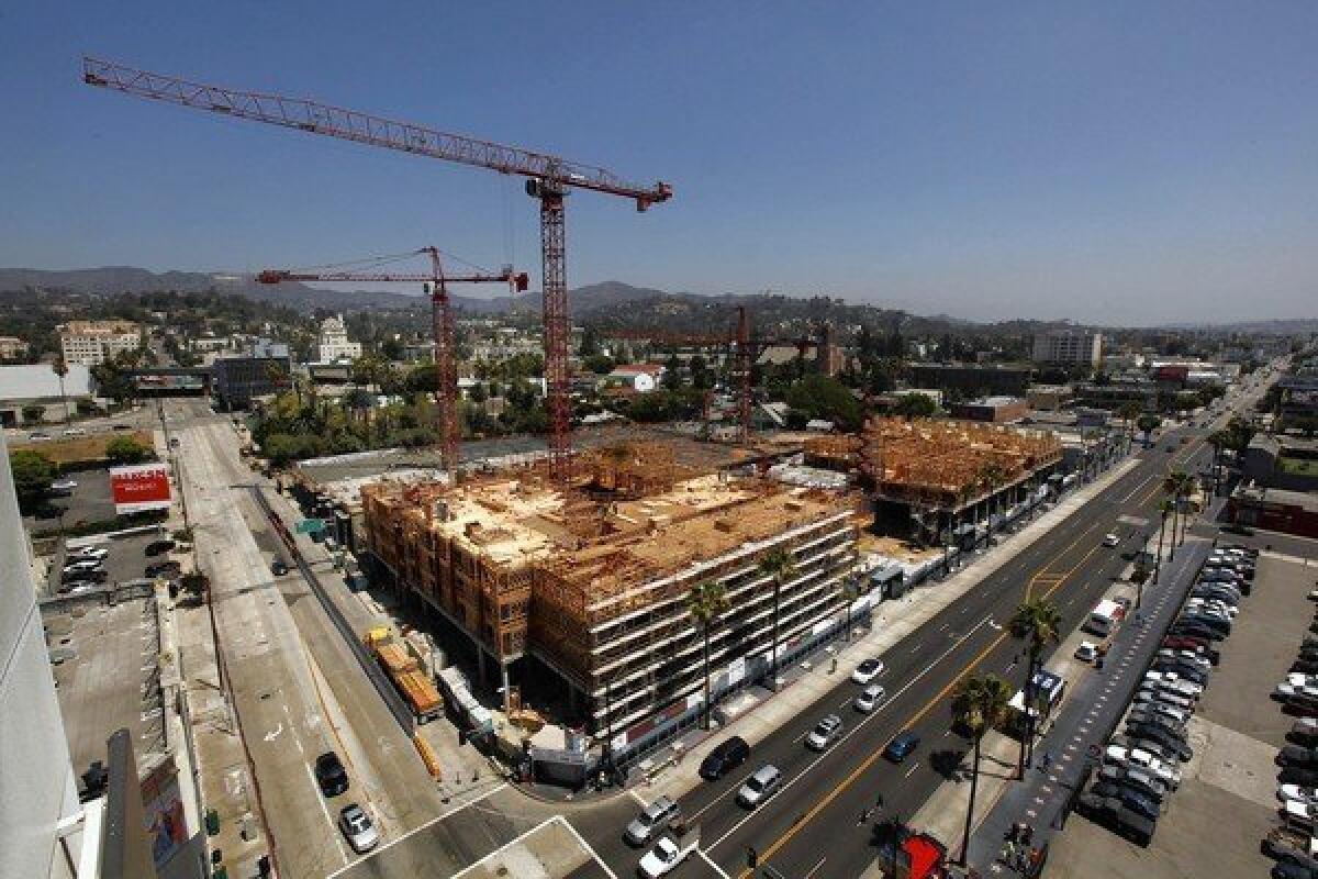
A sprawling $200-million commercial and residential development under construction next to the Pantages Theatre on Hollywood Boulevard was approved by Los Angeles city officials without a seismic evaluation, even though it sits next to an active earthquake fault capable of producing a devastating temblor, according to records and interviews.
Under California law, developers building in seismic zones are required to study the exact location of all active faults mapped by the state.
Those studies involve digging into the ground, looking for signs of the fault. But the state has not yet mapped the Hollywood fault zone, leaving enforcement of the law in a gray area.
Although the city could require a seismic evaluation, it didn’t do so in the case of Blvd6200.
By contrast, the city is requiring the developers of a nearby skyscraper development known as Millennium Hollywood to conduct an intense investigation to look for the fault, including digging a trench.
If any part of a fault is found directly under a proposed project in a state-mapped zone, owners would generally be barred from building within 50 feet, according to the landmark Alquist-Priolo act passed after the 1971 Sylmar quake.
The head of the California Geological Survey, John Parrish, told The Times on Friday that it would be prudent for any developer that close to the Hollywood fault to dig a trench to locate it.
“For a number of years, it’s been known that the Hollywood fault is an active fault,” Parrish said.
“And if you can see these fault scarps on the surface, we would think that the prudent thing to do would be to err on the side of caution and do a site investigation.
“If one intends to build in this zone,” he said, “you need to know exactly where that fault trace is.”
The section of Blvd6200 closest to the fault includes 500 apartments and 74,000 square feet of shop and restaurant space. It borders the foot of a steep slope — north of Carlos Avenue — that is well-documented evidence of the Hollywood fault’s location.
It was also acknowledged by the developer’s environmental impact report.
The hillside formed thousands of years ago when a powerful earthquake punched up one side and the other side sank, creating a cliff that eroded over time to form a slope.
Parrish said the state will soon be mapping that section of the Hollywood fault as part of the state seismic zone survey, which would automatically trigger a state-required seismic study for any building project. That section of Hollywood has seen significant development in recent years.
State budget constraints, he added, have kept his office from mapping the area.
Until the Millennium controversy erupted, he had given mapping the Hollywood fault a low priority because he thought the city was taking responsibility for preventing construction atop the Hollywood fault.
Two of the developers on Blvd6200 project — Frank Stephan of Clarett West Development and Jay Glaubach of DLJ Real Estate Capital Partners — declined comment.
The City Council approved the development in 2007.
The city declined a request to interview city geologist Dana Prevost, who has the authority to order a seismic investigation.
Luke Zamperini, a spokesman for the Los Angeles Department of Building and Safety, said no earthquake fault study for Blvd6200 was required because the property was far enough away on maps used by the building department. The map he was relying on was a 2010 map of earthquake fault activity that shows the general location of faults but is less precise at a block level.
Zamperini wrote in an email to The Times: “Nobody knows precisely where the fault is, but based on the 2010 State Fault Activity Map, [Blvd6200] is far enough south of the fault line indicated on the map to not require a fault study report.”
When asked how far away the Hollywood fault needed to be to require a fault investigation, Zamperini did not specify. But other geologists said it would have been wise had the city required a search for the fault underneath property in that area north of Hollywood Boulevard.
“Any time you’re in a zone at least that near an active fault, the prudent thing to do is really do exhaustive subsurface investigation — just to make absolutely sure you’re not on an active fault strand,” said USC earth sciences professor James Dolan, who mapped the Hollywood fault in the 1990s.
Geologists also warned building owners from making decisions on construction by only looking at fault maps, whether they are published by the U.S. or state geological surveys. None of them are intended to be precisely accurate at the street level. The Hollywood fault is one of many that haven’t yet been zoned under the Alquist-Priolo act.
“You can’t use the lack of an Alquist-Priolo zone anywhere to contradict other evidence at or near the site,” Dolan said.
The developer’s environmental impact report acknowledged the presence of the fault north of the property but said there were no known surface fault traces on the property.
The report also discussed the Alquist-Priolo law but said the closest area fault zone was the Newport-Inglewood fault, “approximately 5 miles south of the project site. Therefore, the likelihood of a surface fault rupture affecting the project site is low.”
A retired state and Orange County geologist said the city should have been more diligent.
“It’s very disconcerting,” said Robert Sydnor, a retired engineering geologist who spent 25 years working for the California Geological Survey.
“If you aggressively go after the search for the fault, then you’ll find it.”
The city should be a “watch-keeper that should be saying, ‘Yes, we would like to know where is the fault,’” Sydnor said.
More to Read
Sign up for Essential California
The most important California stories and recommendations in your inbox every morning.
You may occasionally receive promotional content from the Los Angeles Times.


