May gray and June gloom are threatened by climate change. Enjoy them while they last

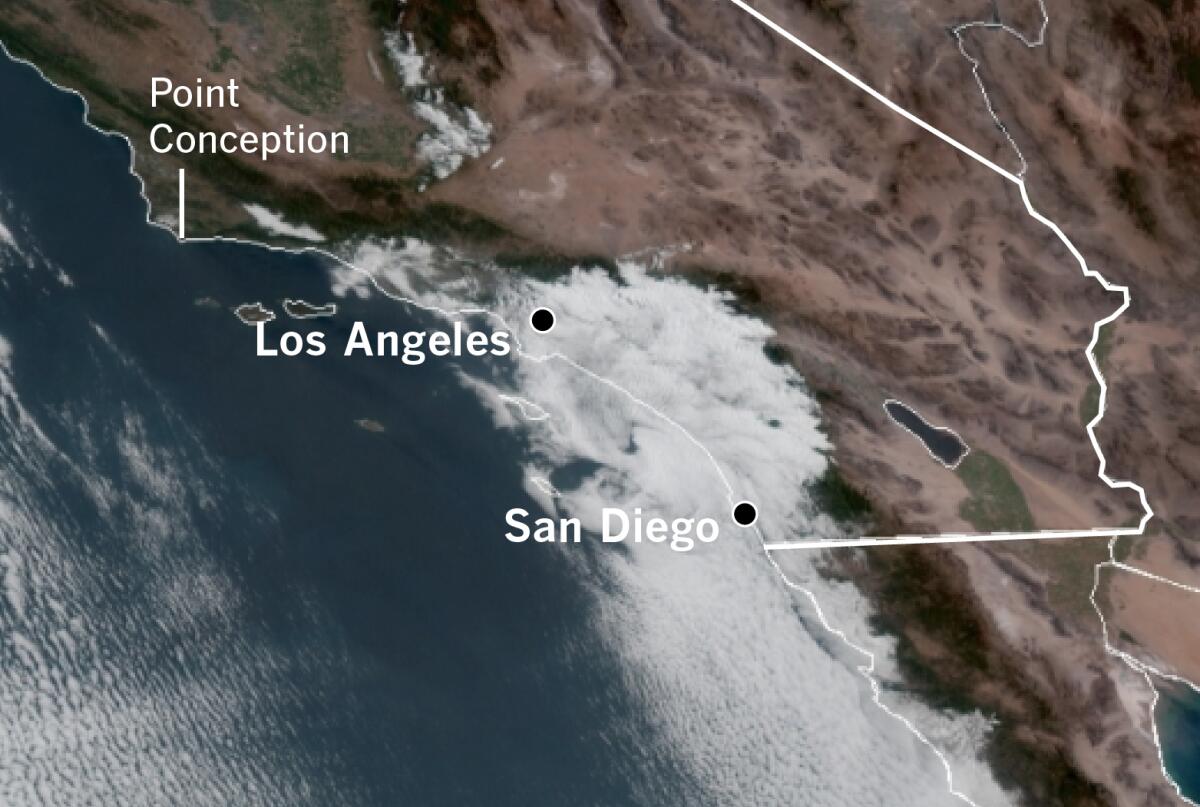
Anyone who has shivered through an overcast Memorial Day at the beach knows that Southern California has a tendency to serve up gray days at this time of the year. Locals call it May gray and June gloom. But the heavy-looking gray clouds that blot out the sun aren’t just the bane of beachgoers. They serve an important environmental role.
The featureless marine-layer stratus clouds occur at low levels of the atmosphere, and they generally don’t produce any rain, although they’re capable of producing drizzle or mist.
More important, they serve as a natural heat shield for heavily populated coastal Southern California, efficiently reflecting the sun’s rays back into space. This cooling effect makes the Southland more livable in the days near the summer solstice, when the path of sunlight is most direct.
“That natural AC is absolutely part of the culture and ecology in California — certainly keeping property values high along the coast,” said John Abatzoglou, a climate scientist at UC Merced.
Even if the clouds clear around midday, as they frequently do, they leave the sun less time to heat up the landscape. When the marine layer is especially deep, some beach spots may struggle to clear, or may not clear at all.
The clouds reflect the sun’s radiation away from the Earth’s surface and modulate the exchange of heat between Earth and space. Without the clouds, the loss of moisture from vegetation is hastened, increasing the summer wildfire potential. In addition, the clouds sometimes add a bit of moisture to vegetation and soil in the form of drizzle.
This effective planetary sunscreen is crucial this year as California braces for a grim summer of heat, continued drought and dangerous wildfire conditions. After a wet December, the state experienced its driest January, February and March on record, when the rainy season was essentially a no-show. Long-range forecasts favor above-normal temperatures across the West this summer.
Extreme heat waves like the one that gripped the West Coast from late June to mid-July last year are caused by exceptionally strong, stubborn ridges of high pressure over the region. They push downward in the atmosphere and squeeze the protective marine layer out. This record heat, which affected much of western North America, is considered an example of how human-caused climate change amplifies weather extremes.
Scientists are studying the ways that climate change may be chipping away at the coastal marine layer. A study published in 2018 found that the frequency of coastal stratus clouds had declined by 20% to 50% since the 1970s as a result of urbanization and production of greenhouse gases. Another study has shown that a decline in coastal fog in Southern California is partly due to the urban heat-island effect — in which concentrations of buildings and paved areas absorb and release more of the sun’s energy than areas covered with greenery.
A Caltech study in 2019 suggested that concentrations of carbon dioxide in the atmosphere could wipe out the marine stratus clouds, which cover about 20% of subtropical oceans, in places such as coastal California and Peru, potentially triggering a spike in global warming.
Another study in April found the evaporative demand, or atmospheric “thirst,” across much of the western U.S. is increasing. Abatzoglou said the onset of morning low clouds and fog may shift a bit into early May as the storm track shifts northward and California sees drier springs. “What that portends for the dissipation of fog season is, well, foggy,” he added.
Marine-layer clouds are among the largest sources of climate uncertainty, said Nicholas Lutsko, an assistant professor at UC San Diego’s Scripps Institution of Oceanography. There’s a growing consensus that there will be less cloud cover in the future, he said, although the reasons are complex. These include factors such as sea-surface temperatures, relative humidity, near-surface winds and atmospheric CO2 levels.
“There isn’t necessarily a smoking gun for explaining why low cloud cover decreases, though there’s a lot of evidence now that it does,” he said.

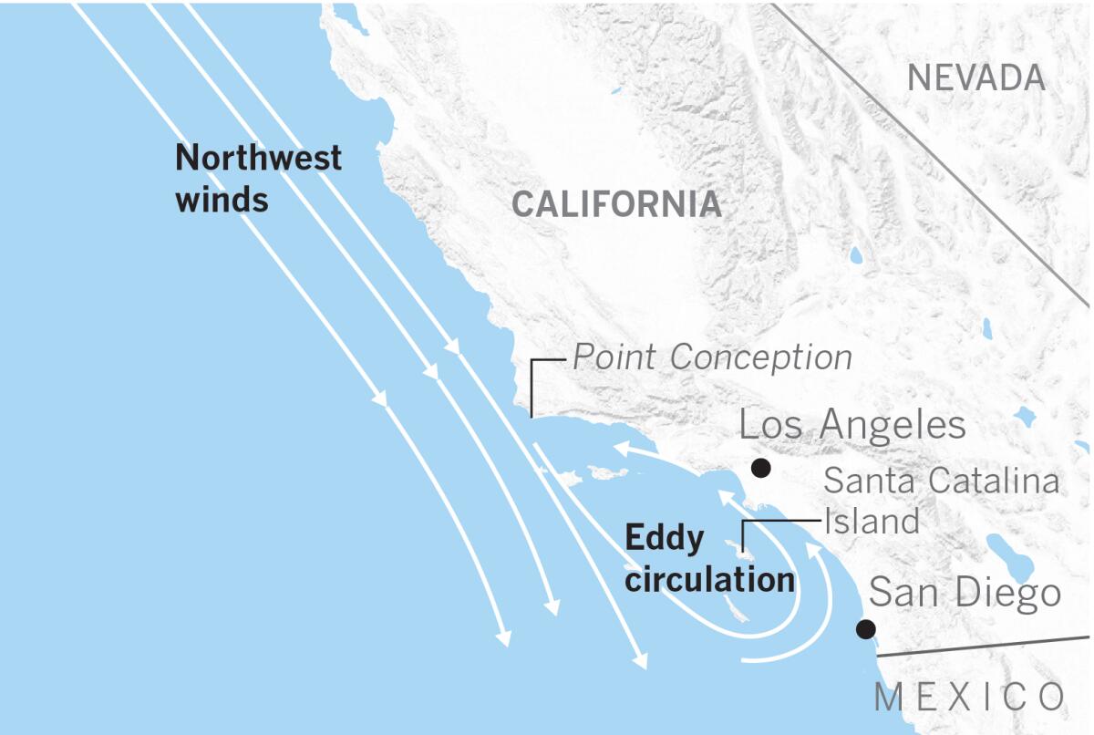
How the clouds form is not a mystery. A semi-permanent area of high pressure sets up over the eastern Pacific in the spring and summer. Meanwhile, there is lower pressure inland in California. Since high pressure flows toward lower pressure, this sets up the prevailing northwest onshore winds that blow along the California coast.
The northwest winds contribute to upwelling, where the cold California Current flows southward from Alaska. Surface waters are pushed aside by the winds and are replaced with cold water from the deep. When moist sea breezes blow across this frigid water, the air is chilled and the water vapor condenses into clouds.
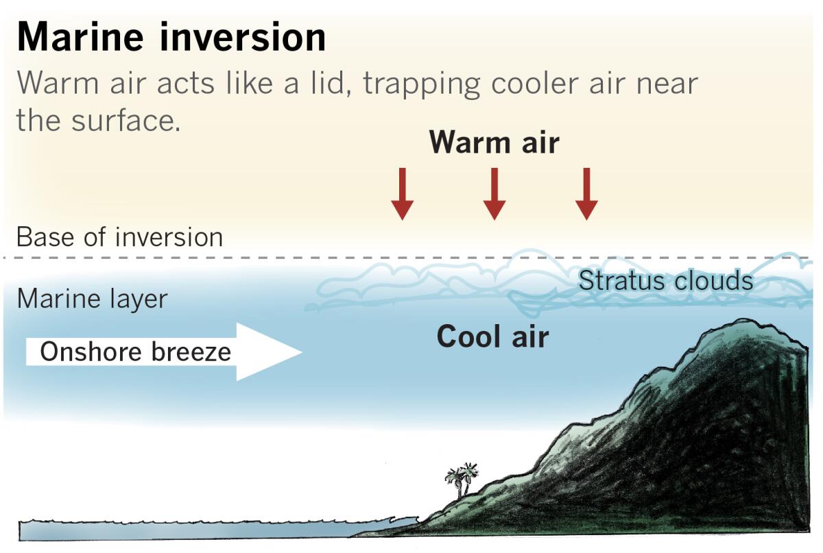
In the atmosphere, temperature normally decreases with altitude. But this chilled layer is much colder than the air immediately above it. The warmer layer acts like a lid or cover trapping the cold air at the surface, in what is called a temperature inversion.
The depth of the marine layer can vary. If the inversion “lid” is shallow or low in altitude, it confines the marine layer to the coastal beaches. For example, high pressure aloft can squeeze the temperature inversion closer to the ground — below 1,000 feet above sea level — creating dense fog. In other words, a cloud that is at ground level, explained Eric Boldt, a meteorologist with the National Weather Service in Oxnard.
If the high pressure overhead weakens, the inversion can deepen to more than 1,000 feet. That allows the clouds to form above the ground, creating less fog. “Once the inversion gets to 1,500 feet or higher, that’s when you begin to see clouds and fog further inland across the San Fernando and San Gabriel valleys, bumping up to the foothills near Pasadena,” Boldt said.
When lower pressure approaches the region, the inversion can lift above 3,000 to 3,500 feet, he said. That would push the marine layer well into the mountains or the canyons of the Antelope Valley.

When the northwest winds come down the Central Coast, they interact with the coastal topography as they round Point Conception, behaving much as water does on the downstream side of rocks or obstructions in a river. They can weaken and turn southeasterly over the Southern California Bight, the sweeping concave curvature of the coast that stretches south to the Mexican Border, and includes the Channel Islands.
These veering winds form a counterclockwise eddy circulation near Catalina Island. This coastal or Catalina eddy acts like a tiny low-pressure system that lifts the air and condenses water vapor into low clouds that can produce night and morning drizzle over the ocean and nearby coastal areas.
With the arrival of summer, high pressure usually strengthens over the Southwest. That eliminates the inversion lid, or there sometimes is weak offshore flow replacing the northwesterly onshore winds. The temperature difference between the ocean and the nearby land is reduced, decreasing significant cloud development. Northwest winds and eddies can persist — although they’re often weaker — in the summer and still occasionally give us clouds near the beaches, Boldt said.
High pressure over the Southwest means beachgoers can expect more clear skies, but the moist, protective marine layer that pushes into the inland valleys earlier in the season is largely gone. That means the region is entirely at the mercy of the sun and its heat, except where monsoon thunderstorms produce late-summer clouds. Next up is autumn, which is the cue for crackling dry Santa Ana winds and high fire danger.


