Bullet train plan for Tehachapi passage would cost $18.1 billion over 82 miles

The future California bullet train would barrel out of Bakersfield and shoot up 4,000 feet over the Tehachapi Mountains en route to Palmdale, an engineering feat that would cost $18.1 billion and impose significant impacts — including the loss of low-cost housing, a homeless shelter and a high school, according to new details.
The impacts are outlined in a draft environmental statement released Thursday by the California High-Speed Rail Authority. It selects a preferred route that would include 9.3 miles of tunnels and 15.8 miles of elevated structures, representing about 30% of the entire passage between the two cities.
The rail segment is a crucial link in California’s ultimate plan of running bullet trains from the Bay Area to Los Angeles and beyond. But this stretch of the route, as planned, would take out the R. Rex Parris High School in Palmdale, the Lancaster Community Homeless Shelter, the Solid Rock Bible Church, eight motels, 253 residential housing units, 311 businesses and 175 farm fields, according to the environmental documents.
Brian Hawkins, assistant superintendent for business services at the Antelope Valley Union High School District, said the site is an alternative high school that serves about 500 students, not a comprehensive campus with football fields and other athletic facilities. Nonetheless, it does have chemistry and biology labs, along with other classrooms and offices.
Hawkins said he was not aware that the documents released Thursday could lead to the loss of the school, though several years ago he saw a map at a rail authority community meeting that showed the site in the way of the rail. “If they get around to building this and we have to move, the question is who is going to pay for it,” Hawkins said.
Rail authority spokeswoman Annie Parker said the authority has “had several conversations with the school district about this and continue to work with them.”
The environmental documents also indicate that a section of the iconic Pacific Crest Trail, which runs from the Mexican to Canadian borders through mountain ranges, forests and deserts, would have to be relocated. The resulting trail would run within sight and sound of the passing 220-mile-per-hour trains. The impacts “would be significant and unavoidable under CEQA,” the report states, referring to the California Environmental Quality Act.
The housing losses would include 34 single family homes, 164 apartments and 55 mobile homes, the authority said.
When and if these impacts would occur is only a guess, since the state lacks the $18 billion to build the section. The rail authority is working under a plan to build 171 miles of rail from Bakersfield to Merced for $20.4 billion, a cost that would consume all of its available funding if it can be completed on schedule by about 2028. But under its 2020 business plan, the rail authority still asserts it can complete the entire Los Angeles to San Francisco system by 2033.
The new documents identify four alternative routes between Bakersfield and Palmdale, along with two options for the alternatives. It selected so-called alternative 2 as causing the least environmental damage.
Some of the other options would have required rerouting Highway 58, a major cross desert freeway that connects Barstow and the Central Valley. One option would have had “significant impact” to a “historic” Denny’s Restaurant. One of the design options was developed to minimize impacts to the César E. Chávez National Monument.
The cost of building over the steep mountain range has grown much more rapidly than the entire project. In 2012, the Los Angeles to San Francisco construction was estimated to cost $68 billion and it has since grown 18% to $80 billion under the 2020 business plan. By contrast, the cost of the Bakersfield to Palmdale section shot up from $7.7 billion in 2012 to the current $18.1 billion, an increase of 135%.
In years past, high-speed rail experts, tunneling engineers and construction managers said the state was woefully underestimating the difficulty of crossing the steep grades that lead to Tehachapi Pass and then winding through Mojave Desert into urban Lancaster and Palmdale.
The modern route would include some massive structures, such as one viaduct extending 4,600 feet, nearly a mile, and another soaring 220 feet, roughly the height of a 20-story building, above the ground, according to the rail authority.
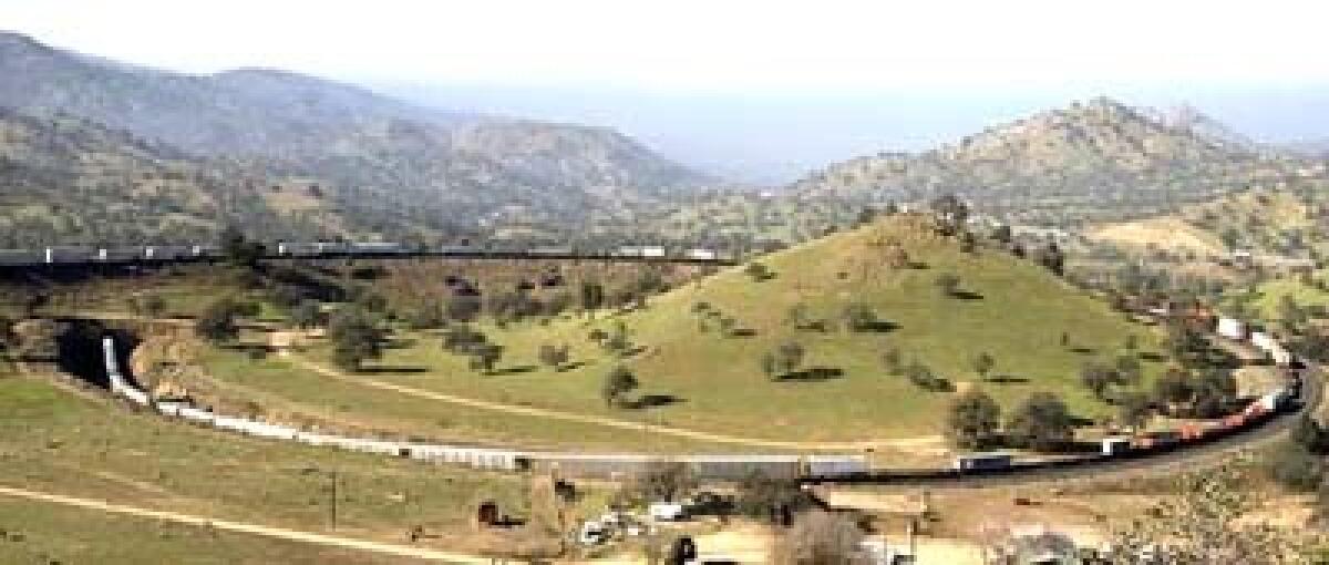
The last attempted rail path through the area was in the 1870s, when Southern Pacific carved out a winding route with thousands of Chinese immigrant laborers, equipped only with dynamite and hand tools. It is still the only rail route between the Central Valley and Southern California.
Since 2015, the rail authority and its consultants have been refining the Tehachapi Mountain crossing and the preferred route identified Thursday has fewer miles of tunnels. Five years ago, studies indicated that it would require 16 miles of tunnels, rather than the current 9.3 miles.
In addition to the tunnels, the route would include 75 overpass or underpass structures as it crosses highways. Another 49 roads in the way would just be closed.
More to Read
Sign up for Essential California
The most important California stories and recommendations in your inbox every morning.
You may occasionally receive promotional content from the Los Angeles Times.


