What is an atmospheric river and why should Southern Californians keep their umbrellas handy?

A new storm fed by the first atmospheric river of the season is expected bring rain to Northern and Central California beginning Saturday, and cause significant travel delays and hazards for Thanksgiving travelers returning home on Sunday, the National Weather Service said.
Based on predictions of its water vapor transport capacity, this atmospheric river is classified as moderate to strong.
Rain from the system is expected to move south into the L.A. region on Tuesday and Wednesday as the atmospheric river weakens, said Lisa Phillips, a meteorologist with the National Weather Service in Oxnard.
After light rain in the late morning to around noon Saturday, rain will intensify in Northern California, with coastal mountain ranges around Big Sur and Santa Cruz forecast to be the wettest, receiving from 6 to 10 inches of precipitation. A flash flood watch is in effect for the area of the Kincade fire in Sonoma County, and high-wind warnings are in effect for the coasts of Sonoma, Marin, San Mateo and Monterey counties.

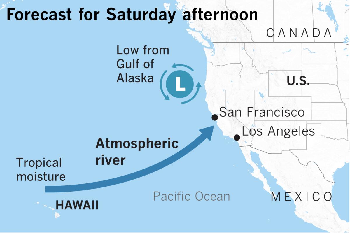
Driving this storm will be an upper-level low-pressure system dropping south from the Gulf of Alaska and setting up off the Pacific Northwest. Its circulation will pull in a plume of extremely moist air originating near the Hawaiian Islands, creating an atmospheric river.
As a result of its origin, this system will be warmer, causing snow levels to start out low — about 3,000 to 4,000 feet on Saturday on the west slope of the Sierra Nevada — then rise to 6,000 feet late Saturday and early Sunday. Snow levels will continue to rise to near or above pass levels Sunday night and Monday.
This atmospheric river thus qualifies as what is popularly known as a Pineapple Express. “All Pineapple Expresses are atmospheric rivers, but not all atmospheric rivers are Pineapple Expresses,” said Drew Peterson, a National Weather Service meteorologist in Monterey.
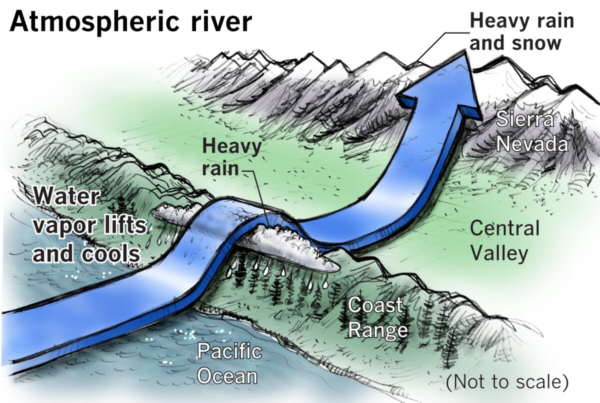
Atmospheric rivers are a concentrated stream of water vapor in the middle and lower levels of the atmosphere. They’re like a continuous conga line of moisture streaming across the ocean without interruption until they encounter an obstacle such as the coast ranges in California. These obstacles force the atmospheric river to start shedding its burden of moisture.
Some atmospheric rivers are weak and produce beneficial rain, and some are larger and more powerful, causing extreme rainfall, floods and mudslides.
On average, 30% to 50% of the West Coast’s annual precipitation comes from a few atmospheric rivers each year.
Atmospheric rivers are roughly 250 to 375 miles wide, and a strong one can transport as much as 7.5 times to 15 times the average amount of water that flows through the mouth of the Mississippi River.
When this atmospheric stream, bloated with moisture as it is, meets the coastal mountains, it is forced up and over the higher terrain. This is called orographic lift. The moist air plume cools as it gains altitude, and the moisture condenses, falling as rain.
Mountain slopes facing the ocean and into the rolling atmospheric river of moisture will receive the heaviest rain, while some areas such as San Jose and parts of the Salinas Valley will be in the rain shadow of these mountains and will receive less rain as a result.
The atmospheric river will continue on across the Central Valley and climb the western slope of the Sierra Nevada. These peaks are so high and give the atmospheric river such a workout that almost all the rest of the moisture is wrung out of it, leaving the mountains smothered in a blanket of snow and the Great Basin beyond parched in a gigantic rain shadow.
A look at the map shows that California’s deserts are a product of mountain ranges, including the Transverse Ranges in the south, that starve inland areas of a moist flow off the ocean.
The mountains serve as the state’s water bank under good conditions, and the snow gradually melts through the warm months, replenishing streams and reservoirs.
Unsettled weather will continue in Northern California for the remainder of next week as the atmospheric river weakens. Showers will linger until midweek and rain will spread south to the Los Angeles region. Yet another storm is on the horizon then, promising more rounds of wet, windy weather in the Bay Area late next week.
More to Read
Sign up for Essential California
The most important California stories and recommendations in your inbox every morning.
You may occasionally receive promotional content from the Los Angeles Times.


