What are red flag warnings?

A red flag warning is an alert issued by the National Weather Service when:
• winds are strong,
• the air is dry, and
• moisture in vegetation is exceedingly low.
Typically, there are two levels of fire weather alerts for the public.
A fire weather watch offers the public notice that, in the next 36 hours, it’s possible that conditions — high winds, low humidity and dry fuels — could develop and result in uncontrollable growth of fire if ignition occurs.
A red flag warning means the National Weather Service has high confidence these dangerous fire conditions will actually come about. Fire agencies deploy resources and equipment during these events so they’re well positioned if a fire does break out.
An “extreme red flag warning” was issued in October 2019 by the weather service’s Oxnard office. It’s an exceptional term meteorologists at that office couldn’t recall ever making before.
The phrasing was meant to emphasize exceptional danger of those particular fire weather conditions, with a forecast of winds gusting up to 80 mph, extraordinarily dry air with no chance for overnight relief, and a spate of recent weather that had already desiccated vegetation.
It was a range of extreme conditions that seemed comparable with the fire weather conditions that led to some of the most destructive fires in state history, such as the 2017 Thomas fire that killed two people and destroyed more than 1,000 structures in Ventura and Santa Barbara counties and the 2018 Woolsey fire that killed three people and destroyed more than 1,600 structures in Los Angeles and Ventura counties.
Red flag warnings ended up being in place for the windiest spots of L.A. and Ventura counties for a continuous 91 hours. That’s unusually long: Red flag warnings typically last only one or two days.
Just days earlier, the weather service office overseeing the Bay Area referred to its own red flag warning as exceptionally dangerous by calling it potentially “historic” and “extreme.” At the time, forecasters in the weather service’s office said the duration of the Diablo wind event, which persisted over two overnight periods, was making conditions particularly dangerous and potentially historic for the region.
The messaging seemed to work. Firefighters credited an extraordinary marshaling of firefighting resources as critical to keeping fires in Northern and Southern California from becoming far worse.
A push from autumn winds
Conventional red flag warnings are already meant to cause the public to take notice. But there’s concern some people might not take them seriously because they’re issued commonly in the autumn.
That’s when California regularly gets strong winds from Nevada and Utah: Dry, high-pressure air speeds into California looking for low-pressure voids on the coast.
As winds rush down mountain slopes or canyon passes, the air dries out even more and heats up, leaving vegetation parched. The winds also give a ride to airborne embers, spreading fires rapidly.
Instead of the common California weather pattern where cool, moist ocean air flows from the Pacific Ocean onto land, wind events that heighten fire weather feature dry desert air flowing from Nevada and Utah toward the California coast.
The winds come from the northeast and head southwest. In Southern California, they’re called Santa Ana winds; in Northern California, Diablo winds. Strong winds are responsible for the rapid spread of many of California’s most destructive wildfires.
The only thing that can end a dangerous fire season is the arrival of rain. But there are signs that California’s autumns are getting drier and autumn rains arriving even later than before, a trend linked to climate change that is expected to become more pronounced over time.
Elevated, critical and extreme fire weather
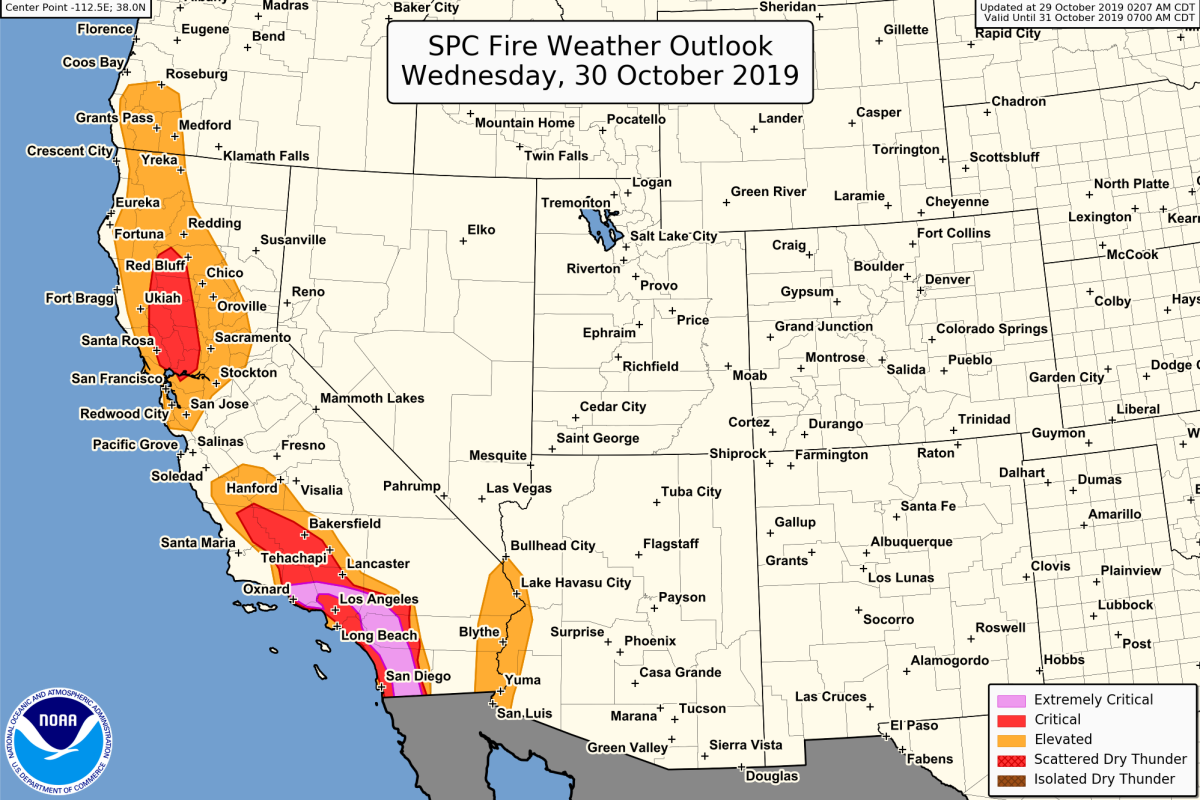
The National Weather Service’s Storm Prediction Center in Norman, Okla., issues a separate fire weather forecast that can map areas of the country into three categories of fire weather: elevated, critical and extremely critical (often shortened to just extreme).

The maps can be helpful to show geographical areas where the fire threat is the most severe. The definitions can vary by region; the below definitions apply to California.
Extremely critical: In California, vegetation is particularly dry; sustained winds are expected at 30 mph over at least three hours; and relative humidity is 10% or less. Temperatures are at least 60 degrees in the winter or 70 degrees in the summer.
Critical: Vegetation is dry; sustained winds are forecast for 20 mph for a duration of three hours or more; relative humidity is 15% or less. Temperatures are at least 50 degrees in the winter and at least 60 degrees in the summer.
Elevated: There is no specific definition. This term can be used where some but not all the criteria for “critical” fire weather are met.
There are also two other categories: “isolated dry thunderstorms,” which refers to an elevated risk from dry thunderstorms, and “scattered dry thunderstorms,” referring to a critical risk from dry thunderstorms.
More to Read
Sign up for Essential California
The most important California stories and recommendations in your inbox every morning.
You may occasionally receive promotional content from the Los Angeles Times.


