Ancient city mapped in Mexico sheds light on the Purepecha
The Purepecha people of Mexico built a large empire in what is now the western state of Michoacan, beating back the Aztecs at a shared border and resisting Spanish colonization until European diseases ravaged the society. Unique among Mesoamerican peoples in many ways -- their language is said to be most related to Quechua, in far-off Peru -- the Purepecha were skilled in crafting copper and pottery but left few clues otherwise about their history and culture.
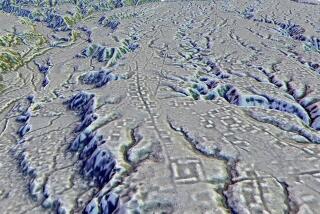
Recent work by archeologist Christopher Fisher and a team from Colorado State University, however, is shedding new light on the group’s history, The Times’ Thomas H. Maugh II reports. Researchers say they have discovered and mapped a previously unknown Purepechan city on Lake Patzcuaro, six miles from the remains of Tzintzuntzan, considered the civilization’s last capital. Fisher believes that the recently mapped city could have operated similarly as a modern “suburb” would to the capital before the Purepecha -- or Tarascans -- consolidated their empire and moved their main ceremonial center to Tzintzuntzan.
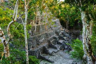
The new urban center, still not officially named, may be as large as two square miles (five square kilometers) and includes house mounds, small temples, plazas, and a pyramid (depicted above), reports Colorado State. The discovery was made in summer 2009 as part of an ongoing survey of the Lake Patzcuaro basin, Maugh writes:
Because the lake level has been dropping, the Purepecha site now sits a couple of miles east of the lake -- Fisher is vague about the precise location because of fears of looting -- but at its height was probably no more than a quarter mile from the shore.
The site sits on a landform called malpais, a young, rugged volcanic landscape “that looks like gravel dumped into a big pile,” he said.
Fisher’s team used handheld computers and GPS receivers to map about 1,300 of the center’s features. The team’s findings were presented last week in St. Louis at the annual meeting of the Society for American Archaeology.
Fisher tells La Plaza that the site is not a government INAH zone, so the risk of looting remains high.
“We are not excavating and are more concerned with the mapping and preservation of the site at the moment,” Fisher said.
More to Read
Sign up for Essential California
The most important California stories and recommendations in your inbox every morning.
You may occasionally receive promotional content from the Los Angeles Times.


