Newly Found Fault Blamed for 1987 Whittier Quake
Previously secret oil company data reveal a major active fault system under metropolitan Los Angeles that most likely caused the magnitude 5.9 Whittier Narrows earthquake in 1987, researchers said Thursday.
This buried fracture may be capable of larger and even more damaging earthquakes than the 1994 Northridge quake, according to the research, published today in Science.
The discovery is the latest in a series of recent findings about regional seismic hazards that have some experts questioning whether earthquake engineering safety standards and building codes in Southern California should be strengthened.
The newly found fault “is clearly a source of major earthquakes and likely could produce much damage to the L.A. area,” said Harvard University geophysicist John H. Shaw, who conducted the study with Peter M. Shearer at the Scripps Institution of Oceanography in La Jolla. “This fault system has not been considered in previous hazard assessments.”
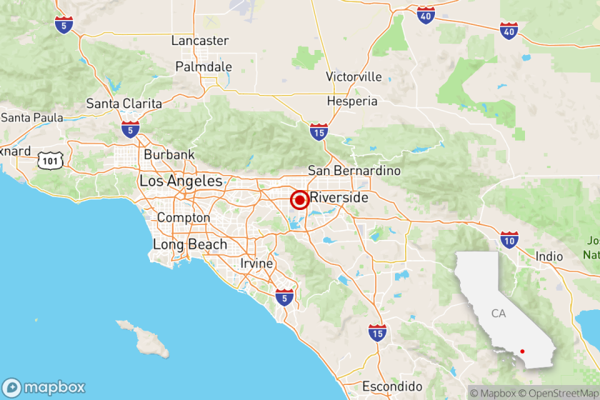
Christened the Puente Hills fault, the newly discovered fault zone runs in three broad segments for almost 25 miles under downtown Los Angeles, through Santa Fe Springs and into the Coyote Hills of northern Orange County. The active fault zone encompasses several hundred square miles of densely settled urban areas.
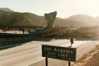
Invisible from the surface, it is a blind-thrust fault system hidden deep in the broken crockery of the Earth’s crust. It is very similar to the fault that caused the magnitude 6.7 Northridge earthquake, which killed 57 people, left 20,000 people homeless and did $40 billion in damage.
Could Produce 7.0 Earthquake
Under the most extreme circumstances, the Puente Hills fault could generate earthquakes as powerful as magnitude 7.0. Its destructive energy probably would most be directed into heavily populated metropolitan areas.
Scientists have long brooded over the possibility that major earthquake faults are hidden under the city. The new research gives the first concrete form to their fears by producing direct images of an active blind-thrust fault concealed beneath the asphalt and steel of urban Los Angeles, according to leading authorities on the geology of the basin.
Even so, the discovery does not seriously increase the overall earthquake risk facing the Los Angeles region, they said, because tectonic energy--and the attendant risk of major earthquakes--is building up in the basin at a relatively constant rate.
“Finding a new fault doesn’t mean that the overall hazard has changed, but that we know more about where an earthquake might occur and how large it is likely to be,” said U.S. Geological Survey seismologist David Ward. “This gives us a much clearer picture of what’s down there.”
Like all of Southern California, the Los Angeles Basin is caught in a vise, compressed at the rate of about a quarter-inch a year by the crushing action of two vast tectonic plates--the Pacific and the North American--jammed against each other.
Most of that energy is released in the rare but explosive movement of an earthquake, in which the slippage of rocks along a fault line can accelerate in an instant from a few fractions of an inch a year to 5,000 miles an hour. Last year, Southern California experienced more than 11,700 earthquakes of measurable magnitude.
To map the Puente Hills fault, the researchers at Harvard and Scripps analyzed seismic data gathered during the drilling of hundreds of commercial oil wells in the L.A. Basin, to which the researchers have recently gained access.
In all, about 40,000 wells were drilled in the basin over the last 50 years to tap the oil and gas trapped in the region’s complex folds and faults, but only a fraction of the information gathered by petroleum company geologists has ever been made public. “This tends to be secretive data,” Shaw said. “It was so expensive to collect. To some extent, it remains a bit of a mystery.”
Assembling the available industry data, which measured how sound waves traveled through the rocks, the researchers created an image of the fault system in the same way that doctors make a sonogram of an unborn child.
Thomas Henyey, director of the Southern California Earthquake Center, endorsed the scientists’ conclusions: They have pinpointed a previously unknown fault, linked it to the Whittier Narrows quake, and mapped it with unusual clarity.
The Whittier Narrows quake, which involved about one-tenth of the fault system, killed eight people, injured 200 and caused $354 million in damage to the Pasadena, Alhambra, San Gabriel and Whittier areas. Until now, many researchers had blamed the Oct. 1, 1987, temblor east of downtown on the Elysian Park system, which runs for 11 miles through the city.
“Prior to now, there was a feeling there was a fault down there, but we could not, in effect, see it,” Henyey said. “The nature of the beast was fuzzy in everybody’s minds.”
The surface of the fault plane cuts across the buried rocks like an angled sheet of paper, with its highest edge slanting up to the west and its deepest to the east.
Its highest point is 1.8 miles underneath Dodger Stadium and the high-rise spires of downtown’s Bunker Hill, experts said. Its lowest known point is more than 9 miles deep, north of Whittier.
By themselves, each of the fault’s three segments could produce a magnitude 6.0-6.5 earthquake, Shaw said, but if all three ruptured simultaneously they could cause a 7.0 temblor.
Armed with their new fault data, Shearer and Shaw then were able to locate the main shock of the Whittier Narrows quake.
“It looks like they have pretty much wrapped up a 12-year-old story, which is what fault produced the Whittier Narrows earthquake,” said Caltech seismologist Kerry Sieh, coauthor with Simon LeVay of a new book on earthquakes called “The Earth in Turmoil.”
Concerns Raised About Buildings
Thomas H. Heaton, a Caltech professor of engineering seismology, said the discovery of a major fault directly under Los Angeles should sharpen concern over the safety of many older concrete frame structures and newer, flexible, steel-frame high-rise buildings in the region.
“When you get into severe shaking, you see very severe damage and potential for buildings to collapse,” Heaton said. “This particular report is confirming the notion that those types of ground motions are feasible for directly under the city.”
Researchers are still struggling to master the bookkeeping of plate tectonics, to learn how earthquakes, fault slippage and seismic energy all balance out in the L.A. Basin.
Many of the best-known faults may never rupture again, while some potentially damaging faults continue to elude detection because they leave no traces at the surface.
USC geologist James F. Dolan called the newest finding “an impressive achievement.”
“It is incredibly important that we know where these active structures are because they are the ones that produce the future earthquakes,” Dolan said.
More to Read
Sign up for Essential California
The most important California stories and recommendations in your inbox every morning.
You may occasionally receive promotional content from the Los Angeles Times.


